A Crowdsourced Project to Map the Amazon

Translations
Image taken from the project's website.
Covering 5.5 million square kilometers (about 1.4 billion acres), and stretching across eight different countries (Brazil, Peru, Bolivia, Colombia, Ecuador, Venezuela, Guyana, and Surinam), the Amazon is both enormous and enormously important. With much of its flora and fauna currently threatened by deforestation and intensive farming, the exploitation of the Amazon by non-renewable and so-called renewable “resource” industries is only making matters worse.
In remote areas like the Amazon, maps and charts for navigation are virtually essential. That's where Mapazonia comes in: an “open project for crowdsource mapping the Amazon region on OpenStreetMap.” With long rivers, a rough landscape, dense vegetation, high temperatures that can reach up to 43°C (109°F), and a host of other spectacles and obstacles, the Amazon can be a very inaccessible place.
Mapazonia highlights just these challenges on its website:
El proyecto nace como iniciativa de la comunidad latinoamericana de OpenStreetMap con el objetivo de llevar adelante mapeos colaborativos sobre terrenos y problemáticas comunes a la región.
The project comes up as an initiative of the OpenStreetMap Latin American community with the aim of carrying out crowdsourced mappings about lands and problems common in the region.
Mapazonia explains:
Nuestro principal objetivo es mejorar el mapa con las geometrías de todos los ríos y carreteras.
Our main purpose is to improve the map with the geometries of every river and roads.
Mapazonia contributes to OpenStreetMap, a collaborative project to create an open and free editable map of the world. Currently, Mapazonia is working on three crowdsource mapping tasks: Acre River sub-basin in Bolivia (81 percent completed), Xingu River basin in Brazil (53 percent completed), and various basins in Colombia (99 percent completed).
Global Voices spoke with Marco Antonio Frías, a member of OpenStreetMap and the Bolivia Mapazonia project. He says the initiative started in early October 2014, during the II Regional Conference of OpenData AbreLatAm and ConDatos, in Mexico City. That was the first meeting of OpenStreetMap communities from Colombia, Mexico, Brazil, Bolivia, Nicaragua, Chile, and Argentina. In the meeting, activists came to focus on reactive activities carried out during humanity emergencies like flooding, earthquakes, and fires.
Later, at the Eighth Annual Conference “State of The Map” OpenStreetMap”,” in Buenos Aires, in early November 2014, the group discussed mapping the river, roads, and bodies of water that make up the Amazon region.
The project would be decentralized and rely on a diverse, self-managed, open and participative world community. Volunteers communicate using a mailing list and an IRC chat channel, and there is an official Twitter account to collect news stories and to celebrate milestones. The community is completely open to everyone—any willing contributor can co-create a map of part of the planet. There are no exclusions made based on language, nationality, location, education level, or anything. And the project is ever trying to expand its pool of contributors.
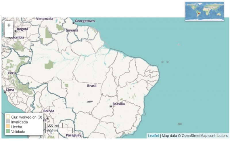
Map of the river Xingu basin in Brazil. Image used with permisssion from Mapazonia project.
Mapazonia uses the open tool Task Manager, developed and led by HOT project, which simplifies the decentralized coordination of mapping tasks.
If you want to contact the project, it's accessible at Twitter and at its own WIki, where it coordinates tasks and resources. More information is available at this blog post.

This post is from Rising Voices, a Global Voices project that helps spread citizen media to places that don't normally have access to it. All Posts


1 comment