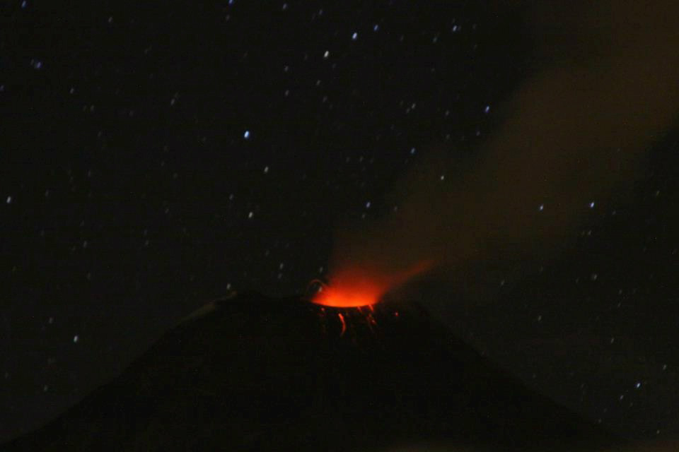
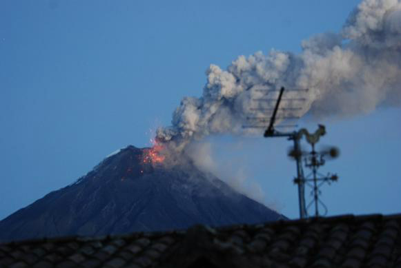
The Tungurahua volcano, an icon and symbol of sovereignty for Ecuadorians, has been registering new activity since the night of August 12, 2012, when incandescence was spotted around the crater zone, as reported by the Geophysical Institute EPN (Polytechnic National School) [es].
The volcano has been spewing pyroclastic material and ash throughout this month, affecting 3,072 families, 4,329 acres of pasture and crops, and 5,700 animals, according to Ministry of Agriculture [es] officials at the time of writing this post.
The “Report on recent activity in the Tungurahua volcano”, published on August 14 on the Geophysical Institute's official website, reported that the volcano's activity had remained “at a moderate to low level.” However, on Sunday, August 5, two moderate explosions were registered, and from then on greater activity has been recorded during the rest of the month.
The same report [es] points out that during the early hours of August 14,
se registró un incremento sustancial del tremor sísmico, acompañado por intensos bramidos que en algunos casos provocaron el vibrar de ventanales en el Observatorio Volcanológico del Tungurahua (OVT), […] en la mañana se reportó caídas moderadas a importantes de ceniza en Pillate y Cusúa (cantón Pelileo) y en Choglontús (cantón Penipe).
Through Facebook [es] and Twitter, the Geophysical Institute (@IGecuador) [es] shares official reports and keeps citizens informed about the latest activity in the Tungurahua. They are also sharing photos, like this one from August 12:
@IGecuador: Volcán Tungurahua: incandescencia en la zona del cráter. Noche 12 de agosto de 2012 pic.twitter.com/jWVMp6Mp
On Thursday, August 16, the Geophysical Institute informed [es] that the volcano had produced a loud cannon sound, generating a constant seismic signal associated with emission and accompanied by roars that shook windows in areas near the volcano.
The report added that incandescent blocks that reached several hundred meters above the crater and then descended down the flanks were also reported.
The situation worsened with the each passing day. On Saturday 18 the National Secretariat for Risk Management (SNGR [es]) declared an orange alert in all areas near the volcano in the Tungurahua province.
Radio Sucre uploaded the following video to YouTube on August 20:
In its August 20 report [es], the Geophysical Institute said that that the volcano had spewed columns of vapor with moderate ash content. These columns, which usually move west, reached maximum heights of 4 km and an average height of 1.5 km over the crater.
The next day, the Geophysical Institute (@IGecuador) [es] shared this photo:
@IGecuador: V. Tungurahua Expulsión de bloques incandescentes durante al atradecer del 20 de agosto 2012. Fuente: G. Ruiz (IGEPN) pic.twitter.com/796j3Ure
The volcano's recent activity is taking a toll on the people living near the volcano. The upper plains and slopes of the Quero canton are covered with a thin layer of ash which has affected potato crops, according to reports by newspaper El Comercio [es].
Recent reports from the same newspaper [es] point out that the volcano spewed pyroclastic material through the creeks of Cusúa and La Pirámide during the afternoon of August 21. With the wind blowing westward, surrounding areas are again suffering from a threat that has generated 12 years of constant alert in the region.
On August 22, Carlos Ureña Moreno (@carlos_urenaM) [es] reported the following from Riobamba, a city affected by the volcano:
@carlos_urenaM: Ya con secuelas de la ceniza ,enfermo , volcán
#Tungurahua dejenos vivir…!!! jejeje , 12 años d lo mismo : (
In its August 22 report, the Geophysical Institute said [es] that a decrease in activity had been registered, “however, evidence in the rest of the monitoring system is still present, like deformation, which indicates that there is still pressure inside the volcano.”
That same day, Pancho Gimenez (@panchojimenezo) [es] informed:
@panchojimenezo: Nueva y fuerte explosión del
#volcán#Tungurahua. Sigue sin poder apreciar. Nublado totalmente
Hours later he added:
@panchojimenezo: hay expulsión de material piroplastico [sic] este momento del
#volcán#Tungurahua
Newspaper El Universo shares recent images of the volcano on its Flickr account. You can also see more photos of the active volcano on the Geophysical Institute's Facebook page.


